Illustrated Directions to the Lower Trailhead
Begin at the I-90 exit for Fairmont Hot Springs/Gregson.
Drive 1.4 miles west toward Fairmount Hot Springs, just past an abandoned railroad grade (the former Milwaukee Road).
Turn left on the Durant Canyon road, just past the abandoned . The road is a public access right-of-way, but passes through the Peterson family ranch. Please respect private property:

As you drive in, you'll see the Butori/Spangler ranch flume on your left. This flume conducts water from a diversion on lower German Gulch to irrigated fields:

The first Peterson ranch gate is 1.0 miles in. It may or may not be open: if it's open, leave it open; if it's closed, leave it closed after you pass through.
The second Peterson ranch gate is 0.3 miles past the first. It's usually closed, and you'll want to leave it that way after you pass through.
The road crosses an active railroad grade 0.1 miles past the second gate. Stop, look and listen before crossing. The trailhead parking lot is on the left just past the railroad tracks. The trail begins as you cross this bridge over Silver Bow Creek:

The initial 0.7 miles of the trail follows a well-marked road that crosses another railroad grade and parallels Silver Bow Creek. Here's a view from that portion of the trail:

At 0.7 miles, you are near the confluence of German Gulch and Silver Bow Creeks. Long ago this was the town of Durant, a stop on the Butte, Anaconda, and Pacific railway. A few structures from the old townsite still stand:

From this point, the trail turns south and follows German Gulch Creek up its valley.
Along the trail are scenic lava rock outcrops:

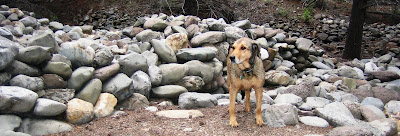
"Chinese Walls"--stones removed from the streambed and neatly stacked by Chinese and other gold miners:

After about a mile above the confluence, the trail goes through a broad, open meadow. It can be a little difficult to follow in the tall summer grass:

Mid-way between the lower and upper trailhead, the trail passes through a narrow canyon and crosses German Gulch Creek on this foot bridge:

Near the upper trailhead, the trail again follows an old road. It eventually meets the main Forest Service road just past the point where the road crosses German Gulch Creek and turns up toward the Beal Mountain Mine. The trailhead is a bit difficult to find from this end, and I hope George Grant TU will mark the way.
The creek is full of westslope cutthroat trout that will eagerly take your fly. Most are 6 to 10 inches long, with the occasional 12 or 14 inch lunker. Please practice catch & release. Mining and smelting pollution in Silver Bow Creek protected this native trout population from hybridization by exotic rainbow trout. Westslope Cutthroat Trout are the true gold of these hills. With care, these beautiful fish will be around for our granchildren and future generations to appreciate:


2 comments:
Beautiful blog, nice post here, and thanks for the great Obama photos (in another post) as well!
Found a "Road Closed" sign when you get to the private property. If you can drive on a long unpaved road, try German Gulch Rd.
Post a Comment